Severe Storm Complex Closing in on Tulsa With Tornado Risk and Flash Flooding
TULSA, OKLAHOMA — A powerful severe storm complex is rapidly approaching the Tulsa metro area and is expected within hours, bringing damaging winds, torrential rain, and a possible spin-up tornado as it moves eastward.
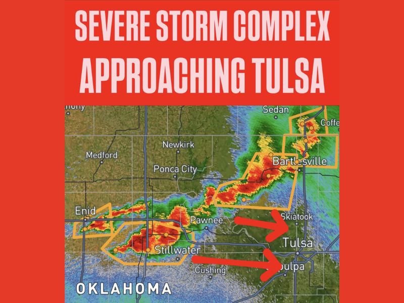
As of 10:15 PM, meteorologists track the intense storm corridor stretching from Enid through Pawnee to Skiatook and northern Tulsa suburbs. Radar images reveal two distinct storm cells targeting Tulsa and surrounding communities, with parts of the complex also threatening Sapulpa to the south and Bartlesville in Washington County to the north.
Primary Hazards Include Damaging Winds and Heavy Rainfall
Forecasters emphasize damaging winds as the leading threat, capable of uprooting trees, snapping power lines, and inflicting major damage on homes and infrastructure. Alongside this, very heavy rainfall could lead to rapid flooding of roadways and low-lying areas, creating hazardous driving and life-threatening conditions.
Although not the main focus, the storm carries a significant tornado risk. Officials have warned residents not to ignore this threat, urging everyone in the Tulsa metro region to seek interior shelter on the lowest floor of a sturdy structure immediately.
Communities in the Direct Path: Tulsa, Skiatook, Sapulpa, and Bartlesville
The storm complex has already impacted Stillwater, Pawnee, and Cushing with severe weather and continues to march eastward toward Tulsa proper. The neighborhoods of Skiatook, Sapulpa, and the northern Tulsa suburbs now face the brunt of the approaching storm as warnings remain active.
Bartlesville and nearby Washington County communities to the north remain within danger zones as separate storm cells move through that corridor under severe weather warnings.
Urgent Safety Instructions for Tulsa Area Residents
Authorities stress immediate action: do not wait for conditions to worsen. Move to a safe interior room away from windows, avoid basements or low spaces prone to flooding, and refrain from driving through flooded streets.
“Treat this situation as a tornado-producing event,” local meteorologists caution, urging all residents to remain sheltered until the severe weather passes.
Emergency services and weather alert systems continue to provide updates, but residents should prioritize personal safety and take no chances.
What’s Next?
The storm complex is expected to move through the metro area over the next several hours, with conditions worsening quickly. After passing Tulsa, the system will continue eastward, potentially affecting communities beyond Oklahoma.
For readers in South Carolina and across the US monitoring this developing situation, the Tulsa storm highlights the importance of storm preparedness and swift response during severe weather outbreaks nationwide.
Stay informed and safe by following live updates from trusted sources and local emergency broadcasts.
For ongoing coverage of this emergency, monitor SaludaStandard-Sentinel.com and The SC Journal for the latest developments.