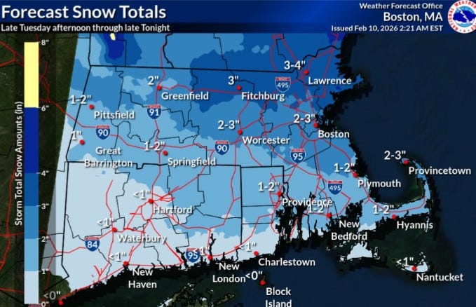
URGENT UPDATE: A fast-moving storm is set to blanket Rhode Island with 1 to 2 inches of snow this afternoon and evening, according to the National Weather Service. As temperatures rise slightly, residents should prepare for a mix of snow and rain, particularly in the southern regions where accumulations will be less than an inch.
The storm will impact the northern two-thirds of Rhode Island more significantly, while parts of nearby Massachusetts could see 3 to 4 inches of snow. While this storm isn’t a major snowmaker, it will contribute to the already substantial snowpack, which remains from a winter that has delivered over 20 inches in January alone and an additional 2.6 inches so far this month.
In Providence, the ground is still covered with approximately 10 inches of snow, a remnant of the relentless cold that has gripped the area. February has been notably harsh, with temperatures averaging 19.9 degrees, making it 10.5 degrees colder than normal for the first nine days. January also brought chillier conditions, averaging 27.4 degrees, which was 2.8 degrees below average.
As we brace for the snow today, temperatures are expected to peak at 34 degrees in Providence, offering a slight reprieve from the extreme cold. Forecasters are also monitoring another potential coastal storm this weekend, which could bring additional snow and cold temperatures to the region.
Residents are urged to stay updated and take necessary precautions as snow begins to accumulate. With the weather conditions rapidly changing, this is a developing story that could impact travel and day-to-day activities across Rhode Island. Stay tuned for further weather updates from the National Weather Service as this situation evolves.