Severe Tornado Threat Escalates Across Great Plains and Great Lakes
Meteorologists are sounding alarms as the final ten days of May 2026 approach, warning of a potentially historic surge in tornado activity stretching from the Great Plains to the Great Lakes region. Emerging data from the European Ensemble Model, a leading long-range forecasting system, signals the atmosphere may develop conditions similar to the violent 2004 tornado season, widely known for its relentless and deadly outbreaks.
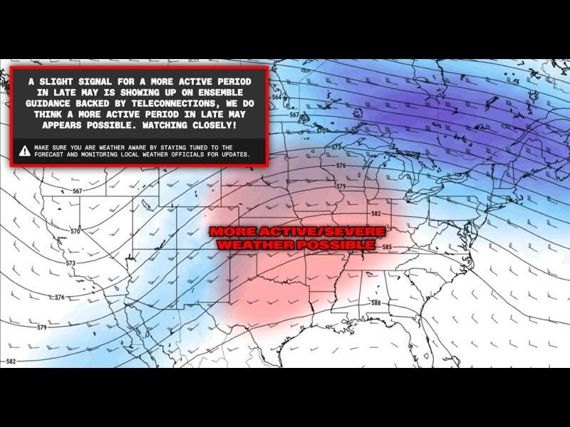
The Euro Ensemble model’s latest runs reveal a developing trough-ridge pattern across the central United States, an atmospheric setup meteorologists identify as a prime trigger for severe weather outbreaks. This dynamic pattern unleashes the essential ingredients for tornado formation: wind shear, ample moisture, and strong instability, all combining to fuel potentially long-track and violent tornado development.
2004 Tornado Season Comparison Raises Concern
The forecast’s most alarming aspect is the comparison to the infamous 2004 tornado season, when sustained, intense tornado activity ravaged multiple states from May into June. If this pattern holds, millions of residents throughout the Plains, Mississippi Valley, and Great Lakes areas face an elevated risk of simultaneous tornado outbreaks with destructive potential.
“While inherent uncertainties exist with long-range forecasts, the Euro Ensemble’s consistent signal, supported by teleconnection data, demands urgent preparedness from communities at risk,” cautioned a leading meteorologist following the May 7, 2026 model run.
Immediate Action Urged for Residents
Authorities are urging residents to activate and verify weather alert systems and revisit severe weather safety plans ahead of this rapidly developing situation. The threat poses a real and growing danger to millions, with forecast updates expected to evolve daily as May progresses.
South Carolina residents and others across the United States should remain vigilant as severe storms often track far and wide, especially during the peak tornado season. Although this outbreak zone focuses on the central US, the potential for disruptive weather impacts beyond remains a possibility.
What to Watch For Next
Forecast models over the coming days will confirm how severe the outbreak will be, with key variables including storm-track development, timing, and strength. Continuous updates from trusted weather sources, including SaludaStandard-Sentinel.com, will provide life-saving information as the situation unfolds.
With peak tornado season now igniting, time is scarce for preparation. Residents in vulnerable areas are urged to stay tuned to local forecasts and begin reviewing storm shelters and evacuation routes today.
National Impact and Outlook
The imminent threat underscores the need for enhanced national awareness and readiness, especially given the increased potential for multiple regions to experience severe weather simultaneously. Emergency management officials nationwide remain on alert.
This late May surge could set the tone for a dangerous summer tornado season, reminding all Americans that severe weather preparedness can mean the difference between life and death.
Stay updated with The SC Journal for all the latest developments on this evolving severe weather threat.